


Voting District 10072, Los Angeles County, California
About
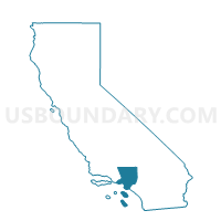
Outline

Summary
| Unique Area Identifier | 533000 |
| Name | Voting District 10072 |
| County | Los Angeles County |
| State | California |
| Area (square miles) | 0.96 |
| Land Area (square miles) | 0.96 |
| Water Area (square miles) | 0.00 |
| % of Land Area | 100.00 |
| % of Water Area | 0.00 |
| Latitude of the Internal Point | 34.07972580 |
| Longtitude of the Internal Point | -118.06539490 |
Maps


Graphs
Select a template below for downloading or customizing gragh for Voting District 10072, Los Angeles County, California


Neighbors
Neighoring Voting District (by Name) Neighboring Voting District on the Map
- Voting District 10051, Los Angeles County, CA
- Voting District 10075, Los Angeles County, CA
- Voting District 10078, Los Angeles County, CA
- Voting District 10717, Los Angeles County, CA
- Voting District 11047, Los Angeles County, CA
- Voting District 55628, Los Angeles County, CA
- Voting District 55637, Los Angeles County, CA
Top 10 Neighboring County Subdivision (by Population) Neighboring County Subdivision on the Map
- Upper San Gabriel Valley CCD, Los Angeles County, CA (323,899)
- Southwest San Gabriel Valley CCD, Los Angeles County, CA (318,982)
Top 10 Neighboring Place (by Population) Neighboring Place on the Map
Top 10 Neighboring Elementary School District (by Population) Neighboring Elementary School District on the Map
- El Monte City Elementary School District, CA (82,353)
- Rosemead Elementary School District, CA (27,178)
Top 10 Neighboring Secondary School District (by Population) Neighboring Secondary School District on the Map
Top 10 Neighboring Unified School District (by Population) Neighboring Unified School District on the Map
Top 10 Neighboring State Legislative District Lower Chamber (by Population) Neighboring State Legislative District Lower Chamber on the Map
Top 10 Neighboring State Legislative District Upper Chamber (by Population) Neighboring State Legislative District Upper Chamber on the Map
Top 10 Neighboring 111th Congressional District (by Population) Neighboring 111th Congressional District on the Map
Top 10 Neighboring Census Tract (by Population) Neighboring Census Tract on the Map
- Census Tract 4812.02, Los Angeles County, CA (6,608)
- Census Tract 4328.02, Los Angeles County, CA (5,821)
- Census Tract 4321.02, Los Angeles County, CA (5,633)
- Census Tract 4336.01, Los Angeles County, CA (4,923)
- Census Tract 4329.01, Los Angeles County, CA (4,464)
- Census Tract 4322.02, Los Angeles County, CA (4,252)
- Census Tract 4323, Los Angeles County, CA (3,951)
- Census Tract 4812.01, Los Angeles County, CA (3,598)
- Census Tract 4329.02, Los Angeles County, CA (3,482)
- Census Tract 4331.01, Los Angeles County, CA (2,281)